
TANDHURSpatial
TANDHURSpatial is an innovative web-based platform designed to assist stakeholders in analyzing spatial data efficiently, accelerating accurate and data-driven decision-making processes.
Free TrialSpatial Data Analysis

Case Projects
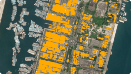
TANDHURSpatial for Solar Panel Installation Potential Analysis
- TANDHURSpatial was utilized as a geospatial tool to assess rooftop potential for solar panel installations in selected areas of Denpasar, Bali.
- Using high-resolution imagery and spatial data processing, available roof surfaces were estimated and visualized through downloadable maps on the TANDHURSpatial dashboard.
- The result offered data-driven insights to support informed decision-making for solar panel deployment.
Year : 2024 | Location : Denpasar, Bali | Client : PLN Icon+